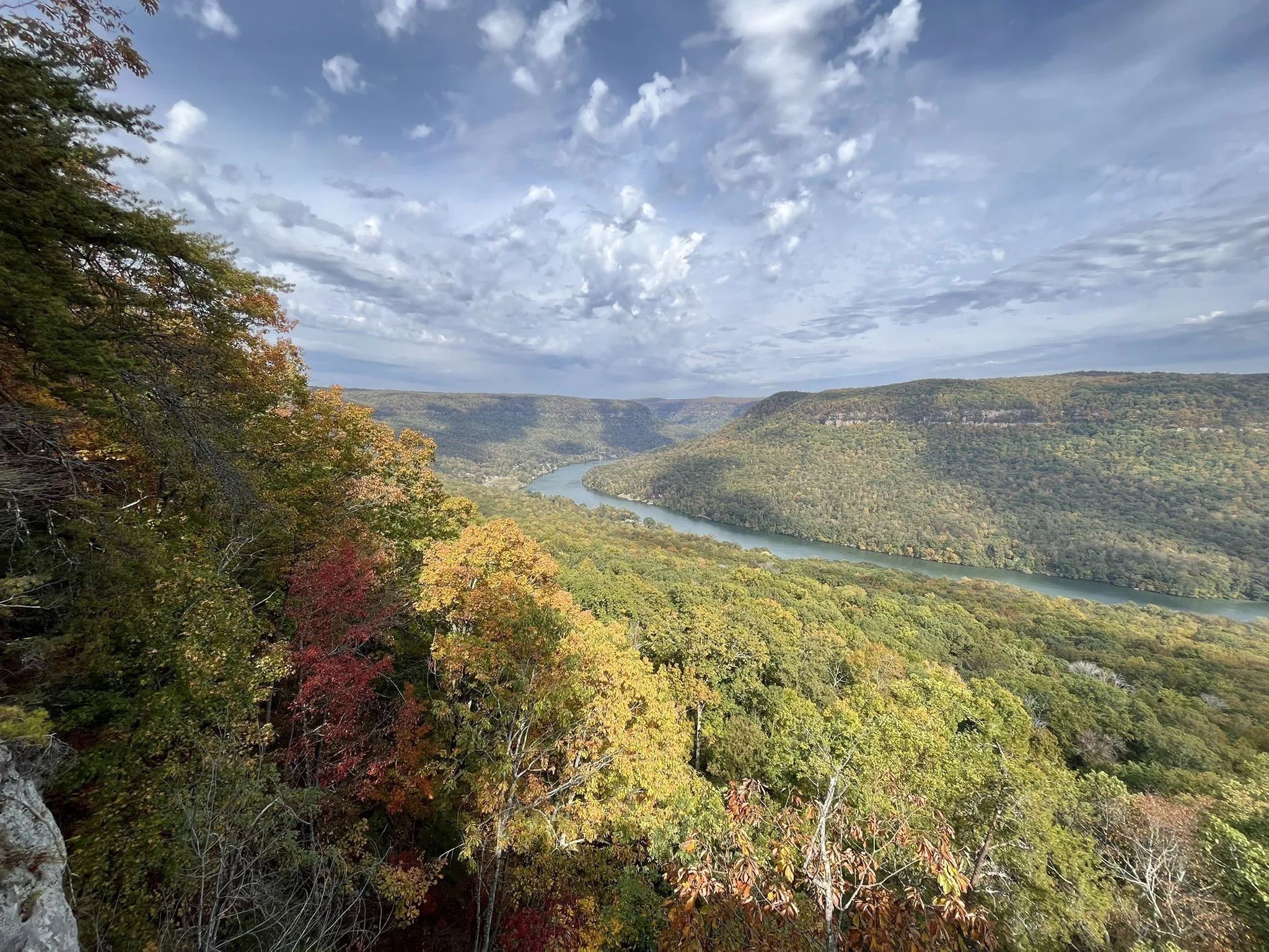
Most views this good make you earn them with miles of hiking. Snooper’s Rock doesn’t. Drive to the upper parking area in Prentice Cooper State Forest, walk a few minutes through the woods, and the trees open onto a sandstone ledge high above the Tennessee River as it bends through the gorge below.
Whether you want a quick scenic stop, a full day on the Cumberland Trail, or the best fall foliage view around Chattanooga, here’s how to plan it, including the gravel roads and closures that catch first-timers off guard.
Snooper’s Rock at a glance
- Location: Prentice Cooper State Forest, about 10 miles west of Chattanooga
- Short walk: About a quarter mile or less each way from the upper parking area
- Longer hikes: About 6 to 12 miles
- Difficulty: Easy from the upper lot, moderate to strenuous on longer trails
- Cost: Free, including parking
- Roads: Several miles of unpaved gravel
- Hours: Sunrise to sunset, with seasonal and hunting closures
- Best for: Big views, photography, hiking, and fall color
Why it’s worth the drive
From the overlook, the Tennessee River curls around the mountains in wide bends, framed by forested ridges that change completely from season to season. It’s one of the most recognizable views in the Chattanooga area.
The name has a story, too. According to the Tennessee River Gorge Trust, lawmen known as revenuers reportedly used the spot to watch for moonshine operations during Prohibition.
Before you go: check for closures
This is the step most visitors miss. Prentice Cooper is also a wildlife management area, and during scheduled managed deer and turkey hunts, the part of the forest west of Suck Creek Road (including Snooper’s Rock) closes to everyone except licensed hunters. Hunts happen throughout the fall and spring.
Many interior forest roads also close each winter, from December 20 through March 15. Snooper’s Rock is listed as staying accessible during that regular winter closure, but signs, barricades, and weather can still change access.
Check the official Prentice Cooper State Forest page for current hunt dates and road closures before you lock in your plans.
Getting there
Snooper’s Rock is close to Chattanooga as the crow flies, but the last stretch is a slow drive on forest roads. From Chattanooga:
- Take US-127 toward Signal Mountain.
- Turn onto TN-27 (Suck Creek Road).
- Continue about eight miles to the Prentice Cooper State Forest entrance at Choctaw Trail.
- Follow Choctaw Trail, then turn left onto Game Reserve Road.
- Follow the signs toward Snooper’s Rock and look for the parking area on the left near the overlook trail.
Get directions to Snooper’s Rock parking.
Download an offline map before you go. Cell service in the forest is unreliable, and the intersecting gravel roads get confusing without one.
Parking and gravel roads
Where you park decides your day. The upper parking area puts you a quarter mile or less from the overlook. The Cumberland Trail parking area, farther back along the Tower Drive corridor, turns it into a hike of about 6 miles round trip.
Expect several miles of loose gravel, potholes, washboard, and occasional mud. Most standard cars make it in dry weather, but the final approach to the upper lot can be rougher, so low-clearance vehicles should take it slow. Drive 25 mph or less, and watch for cyclists and other visitors.
Traveling with a group? Pile into your highest-clearance vehicles instead of caravanning in every car. Fewer cars on a rough road makes for an easier trip in and out.
The short walk to the overlook
From the upper lot, a mostly level dirt path winds through hardwood forest, with roots and rocks underfoot. It’s easy for anyone comfortable on natural terrain, but it isn’t paved or wheelchair accessible. Within a few minutes, you’re standing on the sandstone outcrop.
Stay safe: the overlook is an exposed cliff with no guardrails. Stay well back from the edge, especially when the rock is wet, and keep kids and pets close the whole time.
Longer hikes to Snooper’s Rock
Want to earn the view after all? Three popular options:
- Snoopers Rock Trail via the Cumberland Trail (about 6 miles round trip, moderate): Starts at the Cumberland Trail parking area and winds through hardwood forest and sandstone formations to the overlook.
- Ritchie Hollow Trail (about 8 miles round trip, strenuous): Starts near the river off River Canyon Road and climbs from the bottom of the gorge to the top, passing seasonal Blowing Wind Falls and old moonshine sites.
- Pot Point Loop (about 12 miles, moderate to strenuous): A full-day loop past Ransom Hollow Overlook, big boulder formations, and a natural rock bridge.
For the longer routes, bring extra water, a downloaded trail map, and basic emergency supplies. After a 12-mile day, a hot tub and a real bed beat a long drive home.
The best time to visit
- Spring: Fresh green ridges, blooming mountain plants, and comfortable hiking weather.
- Summer: A lush green canopy over the gorge. Pair it with a swim at the Suck Creek swimming holes, which sit along the same road on the way in.
- Fall: The headliner. Color wraps the river bends, and it’s the most popular time to visit.
- Winter: Bare trees open up the view, but watch for ice on the rock.
Is sunrise worth it? Yes. Morning light on the river and mist settling into the gorge make this a favorite for photographers. The forest opens at sunrise, so plan to arrive right at opening rather than before, and never drive around a closed gate.
Fall foliage weekends are some of the busiest in Chattanooga, so book your stay early. Just check the hunt calendar before you pick dates, since fall hunts can close the overlook.
Make it a day
Snooper’s Rock is about 45 minutes to an hour from Timberroot stays, so it’s best as a morning outing with the rest of the day to spare. A sample day:
- Early morning: Coffee for the road, then head out to catch the view in morning light.
- Mid-morning: Walk to the overlook, or set out on a longer trail if your crew is up for it.
- Afternoon: In summer, stop at the Suck Creek swimming holes on the way back. The rest of the year, add Signal Point on Signal Mountain for another look at the gorge from the other side.
- Evening: Back to your stay for dinner, the hot tub, and comparing photos.
What to bring
- Hiking shoes with good traction
- Plenty of water, especially for longer hikes
- Offline maps or a downloaded trail route
- Layers for cool mornings and changing weather
- Snacks
- A bag to carry out your trash
Where to stay near Snooper’s Rock
Every Timberroot stay in Chattanooga is about 45 minutes to an hour from Snooper’s Rock, with downtown, Lookout Mountain, and Signal Mountain close by for the rest of your trip.
The Valley Collection
About 46 minutes to Snooper’s Rock. Whole homes on quiet streets in Lookout Valley, each with a full kitchen and room for your crew to spread out. Dogs are welcome at select homes, and on leash at the overlook.
Riverview Inn
About 47 minutes to Snooper’s Rock. Fuel up with a complimentary hot breakfast before the drive, then come back to two hot tubs and a heated seasonal pool overlooking the river. Every king room and suite has a private balcony.
Wauhatchie Woodlands
About 47 minutes to Snooper’s Rock. Tiny cabins and custom homes on 14 wooded acres, most with private hot tubs for sore legs after a long trail day. Groups can book several cabins together or take over one of the homes.
Treetop Hideaways
About 48 to 51 minutes to Snooper’s Rock. Five handcrafted treehouses in two locations, one beside Ruby Falls and one in the Chattanooga Valley. A gorge view by day and a night in the trees after.
Quail Run Farm
About 52 minutes to Snooper’s Rock. A 120-acre working farm with converted grain silos, cabins, farmhouses, and tiny homes. Come back from the trail to a cookout with farm-raised beef and a sunset over the pasture.
Lookout Mountain Inn
About 54 minutes to Snooper’s Rock. Cottages, rooms, and apartments in the woods on Lookout Mountain, with breakfast included. Pair the gorge one day with Rock City and Ruby Falls the next.
Snooper’s Rock FAQ
Can you drive to Snooper’s Rock?
You can drive close on Prentice Cooper’s gravel forest roads, then walk a quarter mile or less from the upper parking area. The last stretch is a natural trail, not a paved path.
Do you need four-wheel drive?
Usually not. Standard cars can often handle the main gravel roads in dry weather, but conditions vary, and higher clearance helps on rough or rutted sections. Avoid driving through mud or around closed gates.
Is Snooper’s Rock free?
Yes. Access and parking are free.
Is Snooper’s Rock open during hunting season?
Not during scheduled managed hunts, which close the part of Prentice Cooper west of Suck Creek Road, including Snooper’s Rock. Check the official Prentice Cooper State Forest page before you go.
Can you visit Snooper’s Rock in winter?
Usually, yes. Many forest side roads close from December 20 through March 15, but Snooper’s Rock is listed as staying accessible. Weather and hunt closures can still affect access.
Is Snooper’s Rock safe for kids?
The short walk works for many families, but the overlook is an unfenced cliff. Keep young children close at all times near the edge.
Are dogs allowed at Snooper’s Rock?
Yes, on the forest’s recreational trails. Keep them leashed, especially near the cliff edge.
Where should we stay near Snooper’s Rock?
Every Timberroot stay in Chattanooga is about 45 minutes to an hour away, from whole homes in Lookout Valley to treehouses, tiny cabins, and a working farm.
Popular Posts


Adventure stays here